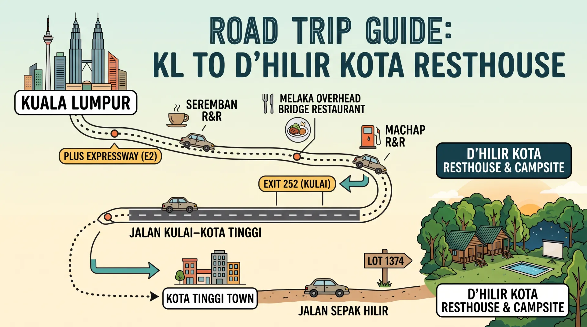
Driving to D’Hilir Kota Resthouse & Campsite from Kuala Lumpur: The Road Trip Guide
Trading the city concrete of Kuala Lumpur for the calm greenery and quiet kampung air of Kota Tinggi is one of the easiest weekend road trips in Peninsular Malaysia. The journey is mostly smooth highway driving, taking you from the capital right to the doorstep of D’Hilir Kota Resthouse & Campsite.
Here is a step-by-step route guide, including driving times, recommended rest stops, and what to expect on the final stretch.
Route Overview & Drive Time
-
Distance: ~350 km (one-way)
-
Driving Time: ~3.5 to 4.5 hours (depending on traffic and stops)
-
Vehicle Type: Any standard sedan, hatchback, or SUV (no 4WD required)
Step-by-Step Driving Directions
1. Cruise South on the North–South Expressway (E2 / PLUS)
-
Head south out of Kuala Lumpur via the Sungai Besi Toll Plaza onto the PLUS Expressway (E2).
-
Settle in for a straightforward southbound cruise past Seremban, Melaka, and northern Johor.
2. Exit at Kulai (Exit 252) or Senai Utara
-
As you approach southern Johor, take Exit 252 (Kulai).
-
From Kulai, follow the directional signage onto Federal Route 94 (Jalan Kulai–Kota Tinggi) heading east directly toward Kota Tinggi town.
-
(Alternative route): You can also exit slightly earlier at Ayer Hitam (Exit 244) if you prefer cruising scenic trunk roads through Kluang, though the Kulai exit offers the fastest and most direct dual-carriageway access into Kota Tinggi.
3. Navigate to Jalan Sepak Hilir
-
Once you arrive near Kota Tinggi town, set your GPS (Waze or Google Maps) to “D’Hilir Kota Resthouse & Campsite” or navigate towards Jalan Sepak Hilir.
-
Turn off the main road and follow the local village access toward Lot 1374.
Recommended Pit Stops Along the Way
Breaking up the drive makes the journey as pleasant as the destination:
-
Seremban R&R (Southbound): A solid first pit stop for fuel, coffee, and light snacks.
-
Ayer Keroh R&R / Overhead Bridge Restaurant: Great halfway mark with ample food options and clean amenities.
-
Machap R&R: Convenient final highway stop before taking your exit into Kulai/Kota Tinggi.
Road Conditions & The Final Approach
-
Paved Until the End: Almost the entire route consists of multi-lane highway and well-paved federal roads.
-
Kampung Road Section: The final stretch approaching the resthouse transitions into a narrower, single-lane village route. Drive at a relaxed pace and yield courteously to oncoming local vehicles.
-
Natural Red Soil: The ground leading into the parking and campsite area features rural red laterite earth. It is completely firm and accessible for normal passenger cars, though your vehicle will likely pick up some dust or road splatter along the way.
Essential Pre-Trip Checklist
-
Toll Balance: Ensure your Touch ’n Go eWallet, card, or RFID has at least RM60 to RM70 loaded for one-way tolls.
-
Navigation: Download offline maps for the Kota Tinggi / Jalan Sepak Hilir area on Google Maps or Waze just in case cellular reception dips on the village approach.
-
Check-In Assistance: If you need live directions on the final turnoff, call ahead directly at +60 16-589 8175.